Maryland Room
The Starin Collection - Maryland
Map of the State of Maryland
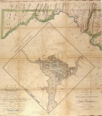
View of the Western section.
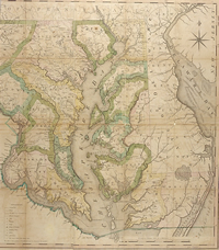
View of the Eastern section.
| Barcode: | 3 3536 00168 5704 |
| Cartographer: | Dennis Griffith |
| Title: | Map of the State of Maryland...and of the remaining Federal Territory; as also a sketch of the State of Delaware. |
| Date of Publication: | 1794 [1795] |
| Place: | Philadelphia |
| Size: | 75 x 131 |
Additional information about this map is available at Maryland Archives.